S-100 - The new standard shaping the future of Navigation
What is S-100?
S-100 is a new data framework that will underpin the next generation of navigation technologies. By providing a universal standard, S-100 will improve the accessibility, compatibility and usability of hydrographic and marine data. This will include the next generation of Electronic Navigational Charts (ENCs), bathymetry, tidal information and more.
These new standards promise to enrich the way data is shared and displayed for maritime and geospatial users. By offering a much more complete picture of the maritime environment, users will be empowered to make more informed decisions based on precise, accurate and timely marine data.
How will S-100 transform the way we navigate?
With dynamic data layers, greater granularity and improved interoperability, the next generation of S-100-enabled solutions will enhance the way decisions are made from ship to shore. From improving navigational safety to helping achieve economic and environmental efficiencies, find out more about the real-world benefits unlocked by S-100 based solutions.
Supporting Safety
By bringing multiple data layers into a single view, S-100 will improve clarity and confidence on the bridge.
The next generation of S-101 ENCs will provide a clutter-free ECDIS display for better usability, while powerful data overlays will provide high-resolution bathymetry and dynamic tidal information to help users navigate complex waterways with ease.
Enhancing efficiencies
With more granular and timely data, S-100 will help enhance efficiencies from ship to shore. By combining bathymetry, water levels and surface currents data, users will have access to dynamic data on the ocean environment and its conditions, providing the basis for more efficient decisions around navigation, cargo loading, and port entry and exit.
Optimising voyages
Dynamic tidal data can support calculations for Just in Time arrivals based on real-time conditions. By taking advantage of favourable tides, users can optimise their fuel consumption for more efficient voyages, reducing emissions and helping to support industry-wide decarbonisation efforts.
Fit for the future
S-100 data is being developed with the future of navigation in mind. Enabled by maritime connectivity, S-100 data sets will be fully machine-readable to ensure they are futureproof for the navigational technologies of tomorrow. This will enable seamless on-board automation, as well as laying the foundations for remotely controlled and uncrewed vessels of the future
Assisting you with every step along the way!
We at Bogerd Martin are closely following up on the latest S-100 developments. Working closely with UKHO and Chart Track, we will be at the forefront of developing user-friendly S-100 solutions to help you and your crew transition safely and with ease.
A new era in navigation is quickly approaching and our team will be there to assist you and your crew every step along the way!
For all questions and inquiries contact us at sales@bogerdmartin.com and get ready for the next generation of data standards!
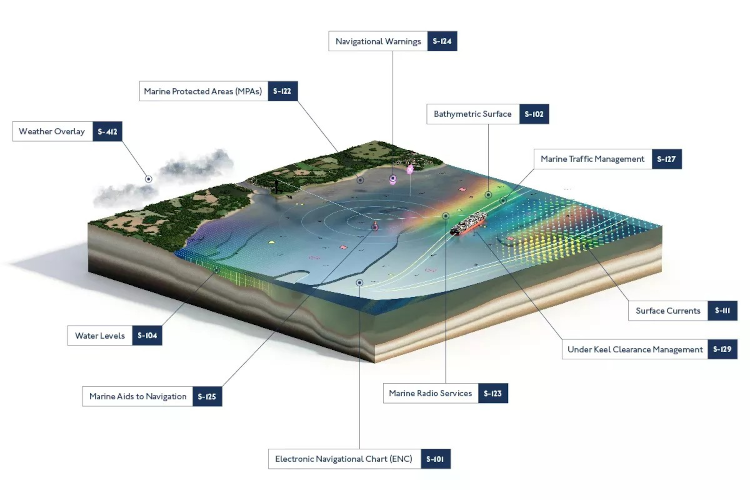
A closer look at some of the S-100 standards in development:
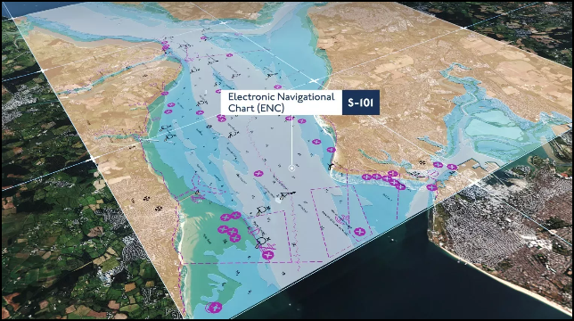 |
S-101 Electronic Navigational Chart (ENC) S-101 is the new standard being introduced for Electronic Navigational Charts (ENCs). In time, S-101 will replace the current standard, S-57 and function as a base layer for all other S-100 products. S-101 will have the same look & feel as S-57 ENCs but will incorporate improvements such as: Intelligent text placement, improved buoyage symbology and improved cyber resilience. |
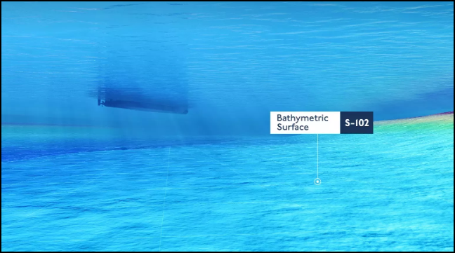 |
S-102 Bathymetric Surface S-102 uses highly detailed data from hydrographic surveys to provide a much more granular view on the shape and nature of the seafloor. This can support more precise navigational decision making, particularly in highly congested or shallow waterways such as port approaches. With greater confidence of the true depth of water underneath the keel, vessels may be able to load additional cargo, resulting in more efficient voyages. |
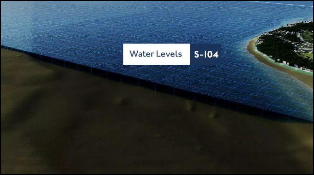 |
S-104 Water Level Information for Surface Navigation S-104 is the new standard for gridded water level predictions and forecasts, replacing static spot predictions with dynamic tidal surfaces designed for use in ECDIS. When combined with S-102 bathymetric surface data and displayed on S-101 ENCs, S-104 enables dynamic under-keel clearance (DUKC) calculations by factoring in predicted tidal heights over time. This allows the safety contour in ECDIS to adjust automatically, giving pilots and port authorities greater confidence in available depth — and potentially unlocking longer tidal windows, increased draught allowances, and safer access through shallow or constrained waterways. |
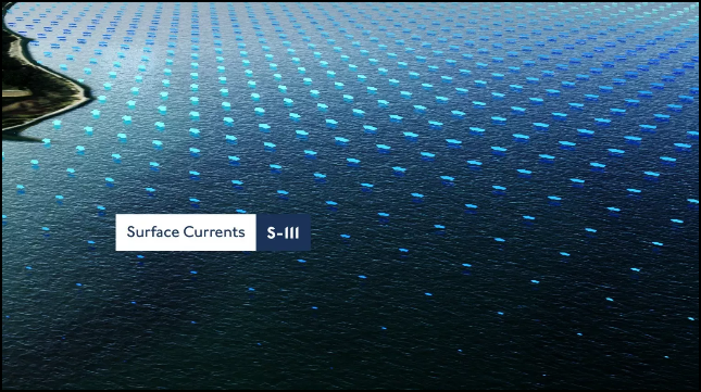 |
S-111 Surface Currents S-111 is the product specification for surface currents, giving ECDIS users a richer, more granular view of complex tidal flows, ebbs and directional shifts. Surface currents data could play a role in supporting more optimised and efficient voyages. |
Bogerd Martin co-operates with Chart Track to provide its customers a wide range of custom software solutions to simplify your daily tasks.
www.charttrack.com